Flux Measurements in the Standard BBO Procedure: A Game-Changer for Risk Assessment
"You can't assess risk without flux"This powerful statement by expert Marjan Joris perfectly captures why flux measurements have become an essential...
4 min read
Getting groundwater monitoring right from the very first installation is not a matter of luck — it is the result of careful preparation. At iFLUX, every project starts with a preliminary assessment: a structured review of available subsurface data, groundwater records, and site-specific conditions that determines where sensors are placed and at what depth. Skip that step, and you risk collecting data from the wrong geological layer, or worse, from a zone where groundwater flux is too low to measure at all. Arthur De Veirman, project manager and hydrogeologist at iFLUX, walks us through what a preliminary assessment involves.
I’m a project manager, so I’m in direct contact with the client. Once a project is initiated, I make sure the sensors end up in the right place in the ground, that everything is executed correctly from a technical standpoint, and that the client ultimately receives the data they need. I also help clients interpret the delivered data and translate the results into actionable insights for their problems or projects.
We always start with a preliminary assessment. We look at what data the client already has and what we can still gather to build a clear picture of the subsurface. At the same time, that first conversation with the client is crucial. We need to fully understand what they’re trying to find out. All of that information is then combined to determine where the sensors should be placed so we can actually answer the client’s questions.
We start with whatever the client already has: borehole logs, cone penetration tests, and so on. Beyond that, we turn to publicly available data sources. In Flanders, for example, we use DOV - the Databank Ondergrond Vlaanderen - which offers a publicly accessible geological 3D model of the subsurface, groundwater levels and other interesting information. Other countries have their own equivalents: national geological surveys, open government databases, or regional environmental agencies often publish similar datasets. We always search for whatever is publicly available in the project area and layer it all together to understand the subsurface and groundwater behavior.
It depends on the scale of the project, but roughly one to two days. Part of that is data collection, and part is processing and summarizing everything, usually in a presentation that we also share with the client. We must explain why we want to install a sensor or drill a borehole at a specific location.
It gives you a clear picture of where to place the sensor. If you were to work blindly and install at an arbitrary depth, you run a serious risk of ending up in the wrong geological layer. That makes the data unusable for the client, which is exactly what we want to avoid. The principle is ‘right first time’: you don’t want to drill, install a sensor, and then realise it should have been done differently.

“Preliminary assessments are the key to ‘right first time’. You don’t want to drill, install a sensor, and then realize it should have been done differently.”
— Arthur De Veirman, Project Manager at iFLUX
That’s something we already evaluate during the sales phase. We always ask where a flux sensor adds real value, and where conventional methods like groundwater level measurements might actually give better results. In one recent project, for instance, we couldn’t deploy the vertical sensors in certain waterways because the surface water was too shallow for a proper installation. In those cases, we think together with the client about how to still deliver relevant data through other means.
We’re currently working on a landfill site where monitoring wells have been installed around a clay barrier wall. Contamination is being detected in several of those wells, and the key question is: is it coming from inside the landfill, or is the drainage system attracting contaminated water in from outside? The preliminary assessment has already given us some leads, but no definitive answer yet. We have been able to rule out faulty well installation which was an important first step. The flux sensors should help us determine the actual direction of groundwater flow and, hopefully, solve the puzzle.
Yes, we can carry out manual boreholes to describe the subsurface, perform groundwater level measurements, slug tests and other relevant tests if needed. In a slug test, we add water to a monitoring well equipped with a pressure logger measuring every half second. You see the water level rise sharply and then gradually recover. From that recovery curve, we can determine the hydraulic conductivity of the subsurface. In other words, how easily water flows through it. That’s one of the essential components for assessing whether a flux sensor can actually measure anything meaningful in that particular soil. In a highly permeable sandy soil, like the coarse beach sand we encountered in Barcelona, the water level can recover within one to five minutes. In a less permeable clay-rich soil, like at one of our Belgian sites, the level hadn’t recovered even after an hour, which tells you something very different about what to expect from a flux measurement.
In September I’m starting a PhD, and one of the core goals is to integrate flux measurements into groundwater models. Through statistical analysis, we want to identify where flux sensors have the greatest impact in reducing model uncertainty. Groundwater modelling is sometimes seen as a competitor to real-time monitoring, but I want to bring the two together: the flux sensor as an essential input to make models more accurate.
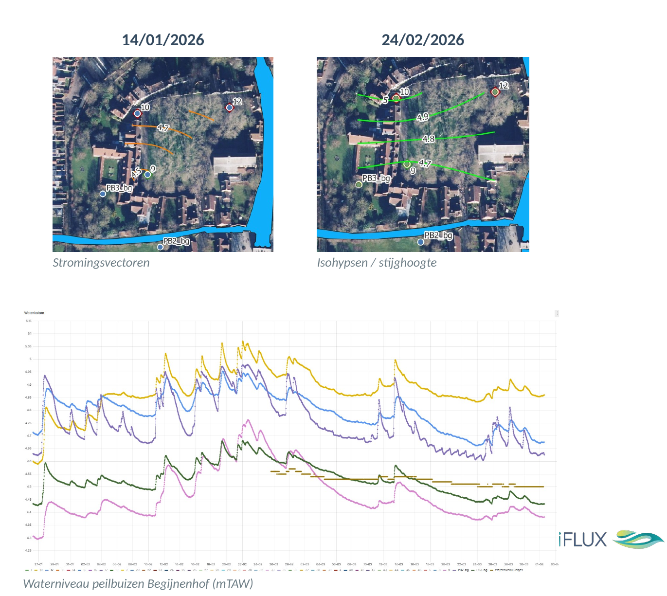
The following examples illustrate how iFLUX approaches a preliminary assessment in practice.
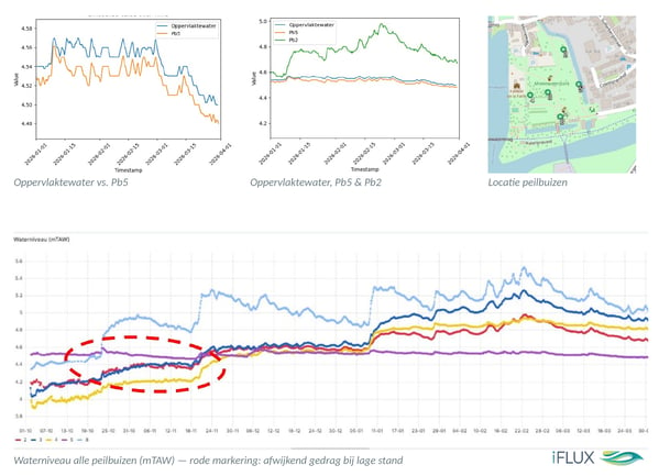
Groundwater levels from existing monitoring wells plotted against surface water levels in the city’s canal network (public source: Waterinfo).
One well closely tracks the surface water pattern; others behave differently — suggesting that the groundwater–surface water connection varies by location and season.

Using measured groundwater levels across multiple wells, an interpolation map is created.
The contour lines reveal the predominant flow direction and help identify which locations will yield the most informative flux measurements.
"You can't assess risk without flux"This powerful statement by expert Marjan Joris perfectly captures why flux measurements have become an essential...

We are excited to announce that PLM Services and iFLUX have joined hands in a strategic partnership that will revolutionize groundwater management...
.jpg)
Campus Vesta, located in the province of Antwerp, is home to one of the most ambitious PFAS remediation experiments in Europe. Together with...